)
)
)
)
 April 22/56 NEWS
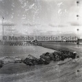
BRIDGE THREATENED: boiling water pound relentlessly at the bride along No. 1 Highway about one mile east of Poplar Point. This photo was taken Sunday afternoon just as department of highway officials and RCMP decided all but essential traffic to stay off the highway. Sightseers were posing a problem. Officials feared the bridge would go and strand many motorists on the wrong side of the bridge.
FLOOD SITUATION LOCALLY
MINIATURE WATERFALL- This is one of the oddities of the Assiniboine flood that caused many motorists to pause for a second looking along No. 1 highway. The water in the centre is cascading down a three-foot embankment. The “waterfall” was caused by the washing out of a roadway two miles east of Poplar Point.
ROAS CLOSED- The sign in the above picture tells the story about all north-south roads between Poplar Point and Portage La Prairie, as floodwaters of Assiniboine cut off all traffic from No. 1 across the river, The above photo was taken off No. 1 showing the road from Poplar Point to Oakville.
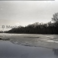
STATIONARY ICE: Cause of most of the flooding on farmlands in the Oakville and Poplar Point area is ice which refuses to break up. This photo was taken looking downstream – eastward from the Baie St. Paul bridge, about 25 miles east of Portage LA Prairie")
(Tashiro) April 22/56 NEWS
BRIDGE THREATENED: boiling water pound relentlessly at the bride along No. 1 Highway about one mile east of Poplar Point. This photo was taken Sunday afternoon just as department of highway officials and RCMP decided all but essential traffic to stay off the highway. Sightseers were posing a problem. Officials feared the bridge would go and strand many motorists on the wrong side of the bridge.
FLOOD SITUATION LOCALLY
MINIATURE WATERFALL- This is one of the oddities of the Assiniboine flood that caused many motorists to pause for a second looking along No. 1 highway. The water in the centre is cascading down a three-foot embankment. The “waterfall” was caused by the washing out of a roadway two miles east of Poplar Point.
ROAS CLOSED- The sign in the above picture tells the story about all north-south roads between Poplar Point and Portage La Prairie, as floodwaters of Assiniboine cut off all traffic from No. 1 across the river, The above photo was taken off No. 1 showing the road from Poplar Point to Oakville.
STATIONARY ICE: Cause of most of the flooding on farmlands in the Oakville and Poplar Point area is ice which refuses to break up. This photo was taken looking downstream – eastward from the Baie St. Paul bridge, about 25 miles east of Portage LA Prairie
- Posted on
- Monday 14 March 2016
- Dimensions
- 2599*2551
- File
- 7397e.jpg
- Filesize
- 2552 KB
- Albums
- Visits
- 1039
- Rating score
- no rating
- Rate this photo
0 comments