)
)
)
)
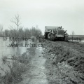
 May 17th, 1955 NEWS ASSINIBOINE RIVER CREST AT WARREN’S CORNER OLD No.1 SAVES EXISTING ? miles east of Poplar Point heavy machinery is in action tearing up the old highway roads ? the weakening dike. The cat’ pulling the scraper is driven by Jack White of Grand View, Man. THE RIVER SPREADS ITS FINGERS, Wilf Lafreniere sets sandbags in place on top of the dike on the farm of Isaac Penner, eight miles east of Poplar Point. Here the river can be seen on the right, considerably higher than the flooded land on the left. Gangs have been working to try and raise the level of the dike. DIKING ON THE ISAAC PENNER FARM. George Huff carries sandbags while his father, Henry, beds them on the dike. This narrow ridge is all that separates the flooding river from the cropland. The river, on the left, is 18 inches higher than the flooded field on the right.")
(Tashiro) May 17th, 1955 NEWS ASSINIBOINE RIVER CREST AT WARREN’S CORNER OLD No.1 SAVES EXISTING ? miles east of Poplar Point heavy machinery is in action tearing up the old highway roads ? the weakening dike. The cat’ pulling the scraper is driven by Jack White of Grand View, Man. THE RIVER SPREADS ITS FINGERS, Wilf Lafreniere sets sandbags in place on top of the dike on the farm of Isaac Penner, eight miles east of Poplar Point. Here the river can be seen on the right, considerably higher than the flooded land on the left. Gangs have been working to try and raise the level of the dike. DIKING ON THE ISAAC PENNER FARM. George Huff carries sandbags while his father, Henry, beds them on the dike. This narrow ridge is all that separates the flooding river from the cropland. The river, on the left, is 18 inches higher than the flooded field on the right.

- Posted on
- Monday 14 March 2016
- Dimensions
- 5574*4414
- File
- 11364c.jpg
- Filesize
- 5765 KB
- Albums
- Visits
- 916
- Rating score
- no rating
- Rate this photo
0 comments