)
)
)
)

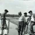
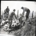
Tashiro May 20 1955 News POPLAR POINT FLOODING The vicinity of the first major washout of the dike five miles east of Poplar Point. A Daily Graphic photographer and reporter were on the scene of the breakthrough shortly after it was reported. Left can be seen the dike, which has been repaired by planking and sandbagging in a final effort to stop the swirling water from breaking through. Centre is a view of the same area taken from one of the boats used to carry sandbags to the first major break. Right, volunteers strengthen the sandbag wall which – the place of the broken dike. It is here that a whole section of the dike, 20 feet long, was completely washed out. Gauging the river – Army personnel and a civilian measure the level of the river about one mile west of Poplar Point in an effort to determine the extent to which the river had risen. The army personnel entered the fight Thursday on instructions from the provincial government. Sandbags delivered by boat – One of the two boats being employed on the “land” of Isaac Penner east of Poplar Point. The bags are filled on the land not yet affected by the flood and then ferried half a mile south to the dike which can be seen in the background. Reading from left to right are, E. Philippi, G. Huff, J. Becker and W. Gowler. Marooned by the flooding river – The well-known landmark of Warren’s store, six miles east of Poplar Point on No. 1 Highway, is shown completely surrounded by the flood waters of the Assiniboine River. This particular flooding was caused by the first major breakdown of the dike almost due south of this point.
- Posted on
- Monday 2 May 2016
- Dimensions
- 2773*1944
- File
- 11359l.jpg
- Filesize
- 4621 KB
- Albums
- Visits
- 952
- Rating score
- no rating
- Rate this photo
0 comments