)
)
)
)

Tashiro May 21/55 News ASSINIBOINE RIVER FLOODING
HIGHWAY No. 1 STANDS HIGH AND DRY. About 11 miles east of Poplar Point the highway presents the only strip of dry land for almost as far as the eye can see. To the right can be seen the line of trees marking the river bank. The river has overflowed completely filling the ditch and inundating the interviewing land. To the left can be seen the flooded farm land. This water is due to seepage and drainage. Much of this land has been underwater since the spring run-off.
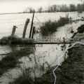
THE RIVER RISES. INSET CAN BE SEEN THE CONDITION OF THE BANK OF THE DIKE NINE MILES EAST OF Poplar Point as it was shown to Daily Graphic readers May 14. The large photograph was taken over the weekend showing the rise in water and the depth to which the river has eroded the bank.
HUMAN CHAIN SWINGS SANDBAGS. Nine miles east of Poplar Point men of No. 1 RCHA form a chain to heft sandbags to the top of the dike. The sandbags are being conveyed by boat to another part of the dike inaccessible by any other means.

- Posted on
- Thursday 2 June 2016
- Dimensions
- 7545*5225
- File
- 11356g.jpg
- Filesize
- 4439 KB
- Albums
- Visits
- 931
- Rating score
- no rating
- Rate this photo
0 comments