)
)
)
)
 Monday, May 23/55 NEWS
Assiniboine Flooding
WHEN THE DIKE BROKE at the farm of Alex Rodd, floodwaters from the Assiniboine overflowed (information missing) La Salle River to the south, covering up at least two bridges only a mile apart. The bridge (information missing) its railing above water Monday afternoon. Both bridges were open Sunday when the (information missing) was toured by the Daily Graphic. An estimated four feet of water covers the bridge.
THE RIVER RISES. Inset can be (information missing) the condition of the bank of the dike nine miles east of Poplar Point as it was shown to Daily Graphic readers May 14. The large photograph was taken over the weekend showing the rise in water and the depth to which the river has eroded the bank.
BRIDGE INUNDATED, BUT GOOD –Standing knee-dep in water, two members of the Daily Graphic staff gaze out toward the hidden site of a bridge, completely covered by floodwaters from the La Salle river. The La Salle was filled to overflowing by the break in the Assiniboine dike on the farm of Alex Ross, three miles west and two miles north of the area shown here. This is part of the water which cut off Oakville from Poplar Point, 13 miles northeast.
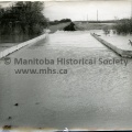
NO.1 HIGHWAY DANGER SPOT – Water laps up to the stringers of this bridge two Poplar Point on No. 1 Highway. A rise in the water here would flood the highway (information missing) west traffic in Manitoba.
ON THE DIKES – it seemed like a never-ending job of filling sandbags with gooey mud along the Assiniboine River in Manitoba last week. But men of the 1st Regiment, Royal Canadian Horse Artillery, took it in good part, day and night. Here two of them bolster the sagging dikes. Left is Bdr. Norman Taylor, Lariviere, Man., with Gnr. Brant, Halifax.")
(Tashiro) Monday, May 23/55 NEWS
Assiniboine Flooding
WHEN THE DIKE BROKE at the farm of Alex Rodd, floodwaters from the Assiniboine overflowed (information missing) La Salle River to the south, covering up at least two bridges only a mile apart. The bridge (information missing) its railing above water Monday afternoon. Both bridges were open Sunday when the (information missing) was toured by the Daily Graphic. An estimated four feet of water covers the bridge.
THE RIVER RISES. Inset can be (information missing) the condition of the bank of the dike nine miles east of Poplar Point as it was shown to Daily Graphic readers May 14. The large photograph was taken over the weekend showing the rise in water and the depth to which the river has eroded the bank.
BRIDGE INUNDATED, BUT GOOD –Standing knee-dep in water, two members of the Daily Graphic staff gaze out toward the hidden site of a bridge, completely covered by floodwaters from the La Salle river. The La Salle was filled to overflowing by the break in the Assiniboine dike on the farm of Alex Ross, three miles west and two miles north of the area shown here. This is part of the water which cut off Oakville from Poplar Point, 13 miles northeast.
NO.1 HIGHWAY DANGER SPOT – Water laps up to the stringers of this bridge two Poplar Point on No. 1 Highway. A rise in the water here would flood the highway (information missing) west traffic in Manitoba.
ON THE DIKES – it seemed like a never-ending job of filling sandbags with gooey mud along the Assiniboine River in Manitoba last week. But men of the 1st Regiment, Royal Canadian Horse Artillery, took it in good part, day and night. Here two of them bolster the sagging dikes. Left is Bdr. Norman Taylor, Lariviere, Man., with Gnr. Brant, Halifax.

- Posted on
- Tuesday 25 April 2017
- Dimensions
- 7416*4956
- File
- 11354a.jpg
- Filesize
- 3382 KB
- Albums
- Visits
- 917
- Rating score
- no rating
- Rate this photo
0 comments